Κούλες
Αντικείμενο
Τίτλος Σημείου Ενδιαφέροντος
el
Κούλες
en
Koules
Σύγχρονη περιγραφή
el
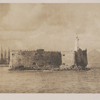
Κούλες, από την τουρκική λέξη kule που σημαίνει φρούριο, είναι το οθωμανικό όνομα του θαλάσσιου φρουρίου Rocca ή Castello a Mare που κτίστηκε από τους Ενετούς και βρίσκεται στην είσοδο του ενετικού λιμανιού, ώστε να προστατεύει το Ηράκλειο από τις εισβολές και τις αποβάσεις των κατακτητών.
Το σημερινό φρούριο κτίστηκε το χρονικό διάστημα 1523-1540, καλύπτοντας επιφάνεια περίπου 3.600.00 τ.μ. Η κατασκευή ξεκίνησε με τη δημιουργία της υποθαλάσσιας βάσης του φρουρίου. Οι Βενετοί για να τη φτιάξουν γέμιζαν παλιά καράβια και βάρκες με πέτρες που έφερναν από το νησί Ντία και τα Φρασκιά και τα βύθιζαν. Οι εξωτερικοί τοίχοι του φρουρίου έχουν μεγάλο πάχος, έως 9 μέτρα, ενώ οι εσωτερικοί είναι λεπτότεροι, έως 3 μέτρα, ανάλογα με τη θέση. Η κάτοψή του είναι τετράγωνη, με μια μεγάλη ημικυκλική προβολή στην ανατολική πλευρά. Το φρούριο ήταν διώροφο και το ισόγειο ήταν χωρισμένο σε 26 διαμερίσματα για διάφορες χρήσεις, όπως αποθήκες τροφίμων, αποθήκες πολεμοφοδίων, δεξαμενές ομβρίων υδάτων και φυλακές. Όλα τα διαμερίσματα φωτίζονταν με μεγάλους φωταγωγούς από τη θολωτή στέγη. Στο φρούριο υπήρχε επίσης φούρνος, μύλος και μια μικρή εκκλησία.
Για την είσοδο στο φρούριο υπήρχαν τρεις πύλες: Δυτικά, Βόρεια και Νοτιοδυτικά, με κύρια πύλη την Δυτική. Στο οικοδόμημα περιμετρικά είχαν εντοιχιστεί διάφορες ανάγλυφες πλάκες, επιγραφές και οικόσημα, καθώς και τρία μαρμάρινα ανάγλυφα που απεικονίζουν τον φτερωτό λέοντα, σύμβολο της Γαληνοτάτης Δημοκρατίας της Βενετίας. Μετά την άλωση του Χάνδακα το 1669, οι Οθωμανοί πραγματοποίησαν επεμβάσεις στο κτίσμα, το οποίο αποκαλούσαν στο εξής Su Kulesi(Φρούριο του Νερού). Σήμερα το φρούριο είναι επισκέψιμο ως αρχαιολογικός χώρος και έχει υποστεί σημαντικές αναστηλωτικές παρεμβάσεις.
en
Koules, from the Turkish word kule meaning fortress, is the Ottoman name of the sea fortress Rocca or Castello a Mare, built by the Venetians and located at the entrance of the Venetian port, to protect Heraklion from the invasions and arrivals of the conquerors.
Today’s fortress was built during the period 1523-1540, covering an area of approximately 3.600,00 sq.m. Its construction began with the creation of the underwater base of the fortress, for which the Venetians filled old boats and ships with stones that they brought from the island of Dia and Fraskia and sank them.
The outer walls of the fortress are thick, up to 9 meters, while the inner ones are thinner, up to 3 meters, depending on the location. Its floor plan is square, with a large semi-circular projection on the east side. The fortress had two floors and the ground floor was divided into 26 apartments for various uses, such as food warehouses, ammunition depots, rainwater tanks and prisons. All the apartments were illuminated through large skylights from the vaulted roof. The fortress also had a bakery, a mill and a small church.
There were three gates to the fortress: the Western, the Northern and Southwestern, with the main gate being the Western one. In the outer walls of the building various relief plaques, inscriptions and coats of arms, as well as three marble reliefs depicting the winged lion, symbol of the Most Serene Republic of Venice, had been fitted. After the fall of Chandax in 1669, the Ottomans carried out interventions in the building, which was called Su Kulesi (Water Fortress).
Today the fortress can be visited as an archeological site and has undergone significant restoration interventions.