Απτέρα
Αντικείμενο
Τίτλος Σημείου Ενδιαφέροντος
el
Απτέρα
en
Aptera
Περιγραφή / Απόσπασμα
89-113
en
EARLY this morning I recommenced my examination of the ancient remains. The monastery is in the midst of them, and is not far from the centre of the ancient city. At a little distance to the south and south-west, I saw traces of two public buildings where several frag ments of shafts of columns, one of which was fluted, were lying near the foundations of walls.

Σύγχρονη περιγραφή
el
Η Άπτερα ή Άπταρα των ιστορικών χρόνων εντοπίζεται στο ύψωμα «Παλιόκαστρο» , που δεσπόζει στα νοτιοανατολικά του κόλπου της Σούδας και είναι μία από τις σπουδαιότερες πόλεις – κράτη της Κρήτης. Η προϊστορική a-pa-ta-wa, γνωστή από κνωσιακές πινακίδες σε γραμμική Β γραφή, πιθανώς εντοπίζεται νοτιότερα, σε χαμηλό λόφο στην περιοχή Αζοϊρέ Στύλου.
Για την προέλευση του ονόματός της υπάρχουν πολλές δοξασίες με επικρατέστερη αυτή που θεωρεί ότι πρόκειται για επίθετο της Αρτέμιδος, προστάτιδας θεάς της πόλης. Κατά μία άλλη εκδοχή το όνομα οφείλεται στον βασιλιά των Δελφών Πτέρα ή Απτέρα. Ο Στέφανος Βυζάντιος πληροφορεί για τον μυθικό αγώνα μεταξύ Μουσών και Σειρήνων, κατά τον οποίο ηττήθηκαν οι Σειρήνες, πέταξαν τα φτερά τους (έμειναν άπτερες), έγιναν λευκές και έπεσαν στη θάλασσα.
Πολλοί αρχαίοι γεωγράφοι ή ιστορικοί αναφέρονται στη θέση της Απτέρας. Σύμφωνα με τον Στράβωνα και τον Πλίνιο, διέθετε δύο λιμένες, την Κίσαμο, η οποία γενικά τοποθετείται στην ευρύτερη περιοχή μεταξύ Καλαμιού και Καλυβών και τη Μινώα, που ταυτίζεται με το σημερινό Μαράθι. Η ταύτιση της θέσης της οφείλεται στον Pashley που περιηγήθηκε την περιοχή το 1834.
Η περίοδος της ακμής της πόλης ξεκινά από τους κλασικούς- ελληνιστικούς χρόνους, φάση κατά την οποία οργανώνονται τα ιερά της, εφοδιάζεται ο κεντρικός οικισμός με ισχυρή, περιμετρική οχύρωση μήκους 3.480μ. και κατασκευάζεται το θέατρο. Τον 4ο αι. π.Χ., κόβει το δικό της νόμισμα και μεταξύ 3ου και 2ου αι. π.Χ. αναπτύσσει σχέσεις με μεγάλα κέντρα της ελληνιστικής επικράτειας. Κατά τη Ρωμαϊκή εποχή (69 π.Χ. - 365 μ.Χ.) η πόλη γνωρίζει νέα ακμή, μάρτυρες της οποίας αποτελούν τα μεγάλα δημόσια κτήρια που σώζονται μέχρι σήμερα. Η κατοίκησή της συνεχίζεται έως τα βυζαντινά χρόνια (7ο αιώνα μ.Χ.), οπότε καταστρέφεται από ισχυρό σεισμό. Στην οριστική καταστροφή της συνέβαλαν επιδρομές Σαρακηνών πειρατών.
Στο χρονικό του Antonio Trivan, το 1182, αναφέρεται η ύπαρξη της Μονής του Αγίου Ιωάννη του Θεολόγου, η οποία λειτούργησε μέχρι το 1962. Οι χώροι της Μονής κατασκευάστηκαν σε κεντρικό σημείο της αρχαίας πόλης με δομικό υλικό από αρχαιότερα, δημόσια κτήρια. Το διώροφο – παλαιότερο κτήριο του μοναστηριακού συγκροτήματος, που διοικητικά υπαγόταν στην ομώνυμη Μονή της Πάτμου, χρονολογείται στις αρχές του 16ου αιώνα.
Οι πρώτες ανασκαφές στην περιοχή έγιναν την δεκαετία του 1860 από τη Γαλλική Αρχαιολογική Σχολή, κατά τις οποίες ήρθε στο φως ο λεγόμενος «τοίχος των επιγραφών», ευμεγέθης δομή με τιμητικές και προξενικές επιγραφές του 3ου και 2ου αιώνα π.Χ.
Το 1942 οι γερμανικές δυνάμεις κατοχής ανέσκαψαν τον μικρό δίχωρο ναό, ενώ το 1958 ξεκίνησαν ανασκαφές από την Αρχαιολογική Υπηρεσία κυρίως με σωστικό χαρακτήρα, τις οποίες συνέχισε αργότερα η ΚΕ΄ ΕΠΚΑ. Από τα έτη 1985-1987 διενεργούνται και συστηματικές έρευνες στον οικισμό.
Η έρευνα, προστασία και ανάδειξη του χώρου ενισχύθηκε ιδιαίτερα από τα Περιφερειακά Ευρωπαϊκά Προγράμματα, κατά τη διάρκεια των οποίων πραγματοποιήθηκαν εκτεταμένες στηρίξεις και σωστικές παρεμβάσεις στην τοιχοποιία των δεξαμενών και των λουτρών (1999-2000 Β΄ΚΠΣ). Μεταξύ 2003- 2006 (Γ΄ ΚΠΣ), αναδείχθηκε μέρος της δυτικής οχύρωσης. Το μεγάλο έργο της αποκάλυψης, συντήρησης, αναστήλωσης και τελικά της ανάδειξης του αρχαίου θεάτρου υλοποιήθηκε από την Εφορεία Αρχαιοτήτων Χανίων (πρώην ΚΕ΄ΕΠΚΑ) με την ένταξή του σε ευρωπαϊκά προγράμματα χρηματοδότησης (2008- 2015 Γ΄ ΚΠΣ-ΠΕΠ Κρήτης).
en
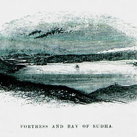
Aptera or Aptara of historical times is located on the hill "Paliokastro", which dominates the southeast of the Gulf of Souda and is one of the most important cities - states of Crete. The prehistoric a-pa-ta-wa, known from Knossian tablets in linear B script, is probably located further south, on a low hill in the Azoire Stylou area.
There are many beliefs about the origin of her name, the most prevalent being the one that she considers to be the surname of Artemis, the patron goddess of the city. According to another version, the name is due to the king of Delphi, Ptera or Aptera. Stefanos Byzantios informs about the mythical battle between the Muses and the Sirens, in which the Sirens were defeated, fluttered their wings (remained wingless), turned white and fell into the sea.
Many ancient geographers or historians refer to the site of Aptera. According to Strabo and Pliny, it had two ports, Kissamos, which is generally located in the wider area between Kalami and Kalyves and Minoa, which is identified with today's Marathi. The identification of its location is due to Pashley who toured the area in 1834.
The period of prosperity of the city starts from the classical-Hellenistic times, a phase during which its sanctuaries are organized, the central settlement is equipped with a strong, perimeter fortification with a length of 3,480m. and the theater is being built. In the 4th c. BC, mints its own coin and between 3rd and 2nd c. e.g. develops relations with major centers of the Hellenistic territory. During the Roman era (69 BC - 365 AD) the city experienced new prosperity, witnessed by the large public buildings that survive to this day. Its habitation continues until the Byzantine years (7th century AD), when it was destroyed by a strong earthquake. Saracen pirate raids contributed to its final destruction.
In the chronicle of Antonio Trivan, in 1182, the existence of the Monastery of Agios Ioannis the Theologian is mentioned, which operated until 1962. The premises of the Monastery were built in a central part of the ancient city with building material from older, public buildings. The two-storey - older building of the monastery complex, which administratively belonged to the homonymous Monastery of Patmos, dates back to the early 16th century.
The first excavations in the area were made in the 1860s by the French School of Archeology, during which the so-called "wall of inscriptions" came to light, a large structure with honorary and consular inscriptions of the 3rd and 2nd century BC.
In 1942, the German occupation forces excavated the small two-room church, while in 1958 excavations were started by the Archaeological Service, mainly of a rescue nature, which were later continued by KED EPKA. From the years 1985-1987, systematic surveys are carried out in the settlement.
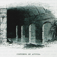
The research, protection and promotion of the area was particularly strengthened by the Regional European Programs, during which extensive supports and rescue interventions were carried out in the masonry of the tanks and baths (1999-2000 BKPS). Between 2003-2006 (DG CSF), it became part of the western fortification. The great work of unveiling, preserving, restoring and finally the promotion of the ancient theater was implemented by the Ephorate of Antiquities of Chania (former KEDEPKA) with its inclusion in European funding programs (2008-2015 DG CSF-CRP of Crete).
There are many beliefs about the origin of her name, the most prevalent being the one that she considers to be the surname of Artemis, the patron goddess of the city. According to another version, the name is due to the king of Delphi, Ptera or Aptera. Stefanos Byzantios informs about the mythical battle between the Muses and the Sirens, in which the Sirens were defeated, fluttered their wings (remained wingless), turned white and fell into the sea.
Many ancient geographers or historians refer to the site of Aptera. According to Strabo and Pliny, it had two ports, Kissamos, which is generally located in the wider area between Kalami and Kalyves and Minoa, which is identified with today's Marathi. The identification of its location is due to Pashley who toured the area in 1834.
The period of prosperity of the city starts from the classical-Hellenistic times, a phase during which its sanctuaries are organized, the central settlement is equipped with a strong, perimeter fortification with a length of 3,480m. and the theater is being built. In the 4th c. BC, mints its own coin and between 3rd and 2nd c. e.g. develops relations with major centers of the Hellenistic territory. During the Roman era (69 BC - 365 AD) the city experienced new prosperity, witnessed by the large public buildings that survive to this day. Its habitation continues until the Byzantine years (7th century AD), when it was destroyed by a strong earthquake. Saracen pirate raids contributed to its final destruction.
In the chronicle of Antonio Trivan, in 1182, the existence of the Monastery of Agios Ioannis the Theologian is mentioned, which operated until 1962. The premises of the Monastery were built in a central part of the ancient city with building material from older, public buildings. The two-storey - older building of the monastery complex, which administratively belonged to the homonymous Monastery of Patmos, dates back to the early 16th century.
The first excavations in the area were made in the 1860s by the French School of Archeology, during which the so-called "wall of inscriptions" came to light, a large structure with honorary and consular inscriptions of the 3rd and 2nd century BC.
In 1942, the German occupation forces excavated the small two-room church, while in 1958 excavations were started by the Archaeological Service, mainly of a rescue nature, which were later continued by KED EPKA. From the years 1985-1987, systematic surveys are carried out in the settlement.
The research, protection and promotion of the area was particularly strengthened by the Regional European Programs, during which extensive supports and rescue interventions were carried out in the masonry of the tanks and baths (1999-2000 BKPS). Between 2003-2006 (DG CSF), it became part of the western fortification. The great work of unveiling, preserving, restoring and finally the promotion of the ancient theater was implemented by the Ephorate of Antiquities of Chania (former KEDEPKA) with its inclusion in European funding programs (2008-2015 DG CSF-CRP of Crete).